We are pleased to announce that, in the context of the SIN’XS project, standardized grid dimensions for datasets are now available.
Following the launch of our open call for data submission, this standardization will enhance the uniformity and consistency of dataset formats, making the data more comparable and usable on the SIN’XS platform.
SIN’XS Dataset Format
The SIN’XS format chosen for third-party dataset submissions adheres to the following specifications:
- Format: NetCDF files, covering a minimum period of 1 month, processed to Level-3.
- Projection: Based on the EASE v.2 format recommended by the National Snow and Ice Data Center (NSIDC), utilizing the Lambert Azimuthal Equal Area polar projection.
- Grid Structure:
- Square grid with even dimensions: This ensures that poles are positioned at the intersection of four pixels.
- Orientation: Longitude 0° is vertical. In the Northern Hemisphere (NH), it is positioned at the bottom (below the pole), while in the Southern Hemisphere (SH), it is at the top (above the pole).
- Coverage: The data grid fully encompasses latitudes down to 50° in both hemispheres, extending up to 31° in the corners.
- Resolution: Options include 12.5 km resolution (712 x 712 pixels) and 25 km resolution (356 x 356 pixels).
The grid is stored from the top-left corner (0,0), with the index varying horizontally to the right (i) and vertically downwards (j). The coordinates of the pixel centres (xc, yc) are defined in meters, with an origin at the pole. Specifically, xc increases horizontally to the right, while yc increases vertically towards the top. For instance, the coordinates of the pixel just at the bottom right of the pole are (+res/2,−res/2).
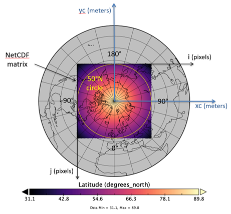
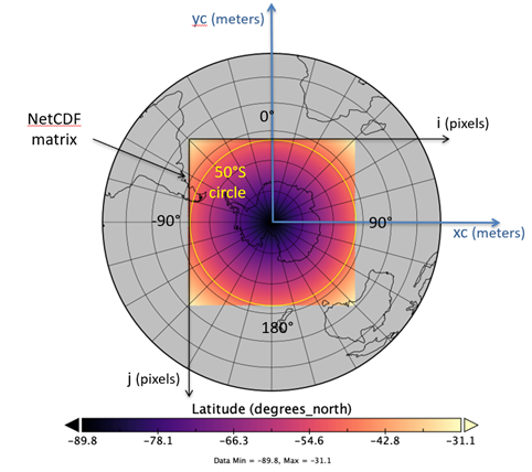
Fig 1. An illustration of the coverage of the SIN’XS grids.
Rationale Behind the SIN’XS Format Choice
The decision to adopt the SIN’XS dataset format is underpinned by several key considerations:
- Standardisation and Comparability: By adhering to a standardised grid format, we ensure that datasets from different sources can be easily compared and integrated. This uniformity is crucial for conducting comprehensive and accurate analysis.
- Projection Accuracy: The Lambert Azimuthal Equal Area projection (EASE v.2) is recommended by the NSIDC for its ability to represent polar regions accurately. This projection minimizes distortion, providing a reliable basis for analysing spatial patterns in these sensitive areas.
- Even Number of Pixels: Using an even number of pixels ensures that poles are precisely located at the intersection of four pixels, which enhances the precision of polar data representation.
- Flexible Resolution: The availability of two resolution options (12.5 km and 25 km) accommodates different levels of detail and computational requirements, making the format versatile for various research needs.
- Consistent Orientation and Storage: The specified orientation (longitude 0° positioning) and storage method (top-left corner origin) streamline data processing and visualization, reducing the likelihood of errors and inconsistencies.
We invite the community wishing to submit their data to SIN’XS to consider this standard format, with our thanks in advance for your collaboration.